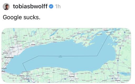
It was unclear in the days immediately following the order whether Google would respect the name change. MapQuest, the 1996 navigation service that still exists but most people stopped using in the early 2000s as Google Maps took over, went viral last week after posting a screenshot of Lake Ontario on X, saying “We’re not changing it.” MapQuest also launched a “Rename Lake Ontario” web toy.
based
Google follows the U.S. Geographic Names Information System (GNIS), which formally changed the name for ‘Lake Ontario’ to ‘Lake America’ in the United States, according to Google’s announcement about the change, posted Saturday: “Since we update Google Maps to reflect name changes in official government sources, which is GNIS for the U.S., people using Maps in the U.S. will see ‘Lake America,’ those in Canada will continue to see ‘Lake Ontario,’ and those outside of the U.S. and Canada will see both names. These updates follow our long-standing policy for bodies of water with names that vary from country to country, and are starting to roll out now.”
I use OsmAnd, which is free on F-Droid. It’s very feature-rich, and I can customize it pretty much exactly how I like. There’s a good tutorial for beginners here.
However, some people prefer the simplicity of the app CoMaps, which is available for Android and iOS. It’s a fork of Organic Maps that arose over disagreements with Organic’s governance (see: open letter).
There are also specialty apps like Alpi Maps for more specialized uses of OSM (in Alpi Maps’ case, hiking).
For contributing to OSM on Android:
I use Vespucci for more complex edits on Android, so things like adding features. (The rough iOS equivalent is Go Map!!.)
I use StreetComplete for a more trimmed-down, gamified experience. It isn’t a power user experience like Vespucci, but it’s often really useful if you’re just on the go and want to make small but meaningful contributions.
The easiest way I’ve found to contribute local information is the iD editor on desktop; it’s the one that pops up if you click ‘Edit’ on OpenStreetMap.org. It strikes a good balance between user-friendliness and power user stuff. For full-on power users, JOSM is a good option. And the easiest way to contribute in a limited way is StreetComplete, which will ask you questions about existing features (like “does this traffic signal have a walk button for pedestrians?”)
Edit: I linked to but forgot to specifically mention the OpenStreetMap Wiki, which is a great general resource.


https://www.404media.co/google-maps-lake-america-lake-ontario-name-change/ more about this for those that live under a rock
based
https://www.openstreetmap.org/
If you have any questions about how you can help or how to use OpenStreetMap, I’m ready and willing answer even your dumbest questions.
Yes, promote OSM. We need more help with this. Crowd-sourced cartography.
Thank you. Do you have favorite android apps? If so, which? What’s the easiest way to contribute local info?
For using OSM on Android:
For contributing to OSM on Android:
The easiest way I’ve found to contribute local information is the iD editor on desktop; it’s the one that pops up if you click ‘Edit’ on OpenStreetMap.org. It strikes a good balance between user-friendliness and power user stuff. For full-on power users, JOSM is a good option. And the easiest way to contribute in a limited way is StreetComplete, which will ask you questions about existing features (like “does this traffic signal have a walk button for pedestrians?”)
Edit: I linked to but forgot to specifically mention the OpenStreetMap Wiki, which is a great general resource.
I also like to use Every Door for businesses, buildings, and small points of interest.